

Overview
The Spatial Summarize tool accepts a single input table, and generates the same schema on output. The tool “summarizes” those input records that share the same Group-by field value by applying the specified operation to the Spatial field.
Spatial Summarize is useful for combining a set of polygons into a single polygon by unioning them together, or for finding the common area of a set of polygons by intersecting them together. This is a helpful tool for any kind of spatial analysis where polygons are processed.
Example:
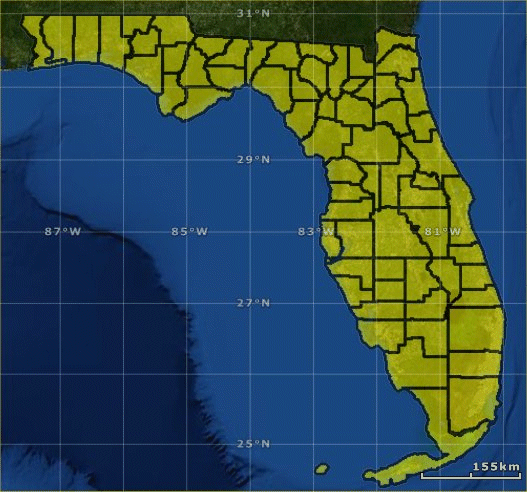
Suppose you start with the county-boundary polygons for the state of Florida from the US Census Bureau (shown here loaded into ESRI ArcGIS Explorer).
Use the Spatial Input tool to read these shapefiles, and apply the Union operation in the Spatial Summarize tool.
All counties are merged into a single polygon.

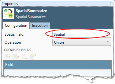
Spatial Summarize tool configuration parameters
The Spatial Summarize tool has a single set of configuration parameters in addition to the standard execution options.
|
Parameter |
Description |
|---|---|
|
Spatial field |
Name of the field containing shapes. This is both the input and output. |
|
Operation |
Type of summary operation to be performed:
|
|
Group-by fields |
List of field names that define the grouping of records. All records having the same values across all of the group fields belong to the same group. Summaries are computed across each group of records, and a single output record is generated for each group. |
Configure the Spatial Summarize tool
-
Select the Spatial Summarize tool.
-
Go to the Input tab.
-
Select the Spatial field.
-
Select the Operation to be performed:
-
Union: (default) the input shape must be polygons, and the output shape is a polygon containing all area of the input shapes, with overlapping areas consolidated.
-
Intersect: the input shape must be polygons, and the output shape is a polygon containing the area that all input shapes have in common.
-
Compose: the resulting shape is the composition (simple addition) of all shapes in the group.
-
-
Under Group-by fields, select the Field grid and choose one or more fields to be summarized.
-
If you choose more than one field, grouping will be primarily by the field on the first row, secondarily by the second row, and so on. If you specify no fields, the entire table is summarized, producing a single group.
-
Optionally, go to the Execution tab, and then set Web service options.