

Overview
Many of the of the Spatial functions require arguments of type Spatial. Data Management's Spatial data type supports the processing of spatial information, including points and polygons. The Spatial Input and Spatial Join tools operate on spatial data, as do a number of spatial functions.
Fields containing spatial data are of type Spatial. A datum of type Spatial may contain one of the following:
-
Point: an (X,Y) coordinate pair. Coordinates must be latitude/longitude degrees, where X=longitude, and Y=latitude. Latitude is in the range [-90...90] and longitude is in the range [-180...180]).
-
MultiPoint: a collection of one or more points.
-
LineSegment: a straight line with two endpoints.
-
Polyline: a collection of line segments, arranged as multiple connected groups.
-
Ring: a closed sequence of points defining a shape.
-
Polygon: a shape created by "connecting the dots" of a set of points.
-
Rectangle
-
Null
-
Error
You can use the Calculate tool to create a new field to hold spatial data.
Shapes that span the date-line (for example, Aleutian Islands or Wangel Island) are handled properly. A geographical projection is applied before any operations that require area or distance computation.
Area
Returns the area of a polygon.
Syntax
Area( polygon)
The required argument polygon must describe a polygon and be of type Spatial.
BoundingRect
Returns a Spatial value that is the bounding rectangle of polygon.
Syntax
BoundingRect( polygon )
The required argument polygon must describe a polygon and be of type Spatial.
Centroid
Returns a Point which is the centroid of a Polygon.
Syntax
Centroid( polygon )
The required argument polygon must describe a polygon and be of type Spatial.
Remarks
This function computes the centroid of a polygon by treating the polygon as a solid two-dimensional object, and computing the "center of mass" of the object.
If the argument polygon is not a Polygon, an Error value will be returned.
The result of this function is a Point. Points are stored using a type Spatial. You can extract the X and Y coordinates of a Point using the PointX and PointY functions.
Example
Centroid(POLYGON)
Compose
Composes similar shape types by simple combination of coordinates, resulting in a multi-part shape.
Syntax
Compose( shape1, shape2 )
The required arguments shape1 and shape2 must be of type Spatial.
Remarks
The following table indicates which shape types can be composed, and the resulting type.
|
Shape type |
Point |
MultiPoint |
LineSegment |
Polyline |
Rect |
Polygon |
|---|---|---|---|---|---|---|
|
Point |
MultiPoint |
MultiPoint |
invalid |
invalid |
invalid |
invalid |
|
MultiPoint |
MultiPoint |
MultiPoint |
invalid |
invalid |
invalid |
invalid |
|
LineSegment |
invalid |
invalid |
Polyline |
Polyline |
invalid |
invalid |
|
Polyline |
invalid |
invalid |
Polyline |
Polyline |
invalid |
invalid |
|
Rect |
invalid |
invalid |
invalid |
invalid |
Polygon |
Polygon |
|
Polygon |
invalid |
invalid |
invalid |
invalid |
Polygon |
Polygon |
ConvexHull
Calculates the smallest-area polygon that completely encloses all of the points or vertices of shape.
Syntax
ConvexHull( shape )
The required argument shape must be of type Spatial.
Remarks
This function calculates the smallest-area polygon that completely encloses all of the points or vertices of the shape. This polygon is often simpler (contains fewer vertices) than the original polygon. A good visualization of the convex hull is to think of an infinitely stretchy rubber band that is stretched around the shape and then allowed to shrink as far as possible while still containing the original shape.
See also https://en.wikipedia.org/wiki/Convex_hull.
CountParts
Returns the number of component shapes within the given shape.
Syntax
CountParts( shape )
The required argument shape1 must of type Spatial.
Remarks
This function returns the number of component shapes within the given shape, as follows:
-
Polygon: the number of sub-polygons or "rings".
-
Polyline: the number of disconnected polylines.
-
Multipoint: the number of points.
-
Point: 1.
-
Rectangle: 1.
-
Linesegment: 1.
See also related function Compose, and related tools Spatial Summarize and Spatial Decompose.
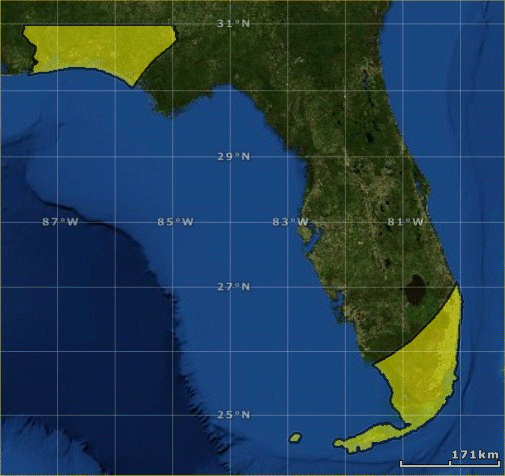
Cut
Subtracts the area of shape1 from shape2.
Syntax
Cut( shape1, shape2 )
The required arguments shape1 and shape2 must of type Spatial, and shape2 must be a polygon.
Remarks
The Spatial value shape1 may be of any Spatial type. For example, if shape1 is a polyline, the function removes the parts of the line segments that fall within shape2. If shape1 is a multipoint, the function removes the points that fall within shape2.
Example
Start with a polygon containing the outline of the state of Florida and an arbitrary circle (shown here in ESRI ArcGIS Explorer).
Cutting the circle from the state of Florida outline results in this shapefile.
Deflate
Decreases the size of a polygon.
Syntax
Deflate( polygon, unit, amount )
The Deflate function syntax has the following arguments.
|
Part |
Description |
|---|---|
|
polygon |
(Required) Must describe a polygon and be of type Spatial. |
|
unit |
(Required) Literal string specifying unit of measurement for amount. Must be one of:
|
|
amount |
(Required) Amount by which to trim the polygon perimeter. |
Remarks
This function trims the perimeter of the polygon by the defined amount, reducing its size uniformly.
FixPolygon
Corrects polygon ring orientation.
Syntax
FixPolygon( polygon )
The FixPolygon function returns a new polygon whose interior rings are oriented counter-clockwise, and whose exterior rings are oriented clockwise. This is the convention used by most geospatial software. You may need to use this if you have used the Spatial Process tool to create polygons from points, or if you have composed multiple polygon rings without ensuring the correct orientation.
The behavior of polygons with intersecting rings is undefined, as the function cannot determine which should are interior and which are exterior.
Remarks
A polygon shape may contain more than one closed ring of points. Non-overlapping rings denote disjoint parts of the polygon, like the Hawaiian islands. Rings that are enclosed in other rings are “holes”, like lakes on land.
GreatCircleDistance
Computes the "Great Circle Distance" between two geographical points.
Syntax
GreatCircleDistance( lat1, lon, lat2, lon2, unit )
The GreatCircleDistance function syntax has the following arguments.
|
Part |
Description |
|---|---|
|
lat1 |
(Required) Numeric latitude of first point in degrees (NAD datum). |
|
lon1 |
(Required) Numeric longitude of first point in degrees (NAD datum). |
|
lat2 |
(Required) Numeric latitude of second point in degrees (NAD datum). |
|
lon2 |
(Required) Numeric longitude of second point in degrees (NAD datum). |
|
unit |
(Required) Literal string specifying unit of measurement for returned result. Must be one of:
|
Remarks
This function calculates the shortest distance over the earth's surface between two points.
InflateRound
Increases the size of a polygon, producing rounded corners.
Syntax
InflateRound( shape, unit, amount )
The InflateRound function syntax has the following arguments.
|
Part |
Description |
|---|---|
|
shape |
(Required) Must describe a polygon and be of type Spatial. |
|
unit |
(Required) Literal string specifying unit of measurement for amount. Must be one of:
|
|
amount |
(Required) Amount by which to trim the polygon perimeter. |
|
npoints |
(Required) The number of points used to approximate the continuous curve of the rounded corner. Must be an Integer >4 and <1000. |
Remarks
This function adds the defined amount to the perimeter of the polygon, increasing its size uniformly. At corners, produces rounded ends, using npoints points to approximate circle arcs.
InflateSquare
Increases the size of a polygon, producing square corners.
Syntax
InflateSquare( shape, unit, amount )
The InflateSquare function syntax has the following arguments.
|
Part |
Description |
|---|---|
|
shape |
(Required) Must describe a polygon and be of type Spatial. |
|
unit |
(Required) Literal string specifying unit of measurement for amount. Must be one of:
|
|
amount |
(Required) Amount by which to trim the polygon perimeter. |
Remarks
This function adds the defined amount to the perimeter of the polygon, increasing its size uniformly. At corners, produces square ends.
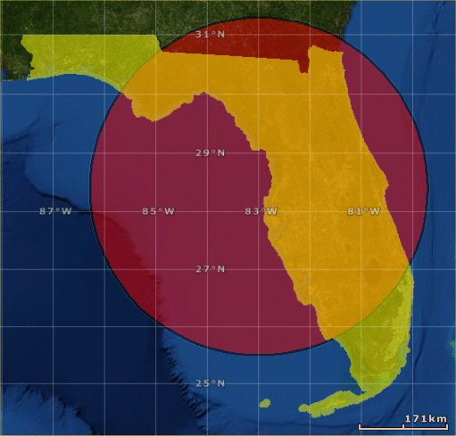
Intersect
Intersects two polygons, returning a new polygon that contains only the overlapping area of the two.
Syntax
Intersect( polygon1, polygon2 )
The required arguments polygon1 and polygon2 must describe polygons and be of type Spatial.
Example
Start with a polygon containing the outline of the state of Florida and an arbitrary circle (shown here in ESRI ArcGIS Explorer).

Intersecting the circle and the state of Florida outline results in this shapefile.
IsLineSegment
Tests whether a shape is a line segment.
Syntax
IsLineSegment( shape )
The required argument shape must be of type Spatial.
Remarks
This function returns True if the given spatial object shape is a line segment.
IsMultiPoint
Tests whether a shape is a collection of points.
Syntax
IsMultiPoint( shape )
The required argument shape must be of type Spatial.
Remarks
This function returns True if the given spatial object shape is a collection of points.
IsPoint
Tests whether a shape is a point.
Syntax
IsPoint( shape )
The required argument shape must be of type Spatial.
Remarks
This function returns True if the given spatial object shape is a point.
Example
IsPoint(MakePoint(40.2, -105.3)) returns True.
IsPolygon
Tests whether a shape is a polygon.
Syntax
IsPolygon( shape )
The required argument shape must be of type Spatial.
Remarks
This function returns True if the given spatial object shape is a polygon.
Example
IsPolygon(SPATIAL_FIELD)
IsPolyline
Tests whether a shape is a polyline.
Syntax
IsPolyline( shape )
The required argument shape must be of type Spatial.
Remarks
This function returns True if the given spatial object shape is a polyline.
Example
IsPolygon(SPATIAL_FIELD)
MakeCircle
Returns a circle constructed from coordinates and the specified radius.
Syntax
MakeCircle( lat, lon, unit, radius, npoints )
The MakeCircle function syntax has the following arguments.
|
Part |
Description |
|---|---|
|
lat |
(Required) Numeric latitude of center point in degrees (NAD datum). |
|
lon |
(Required) Numeric longitude of center point in degrees (NAD datum). |
|
unit |
(Required) Literal string specifying unit of measurement. Must be one of:
|
|
radius |
(Required) Numeric. |
|
npoints |
(Required) The number of points used to approximate the continuous curve of the circle. Must be an Integer 4-1000 (inclusive). |
MakeLineSegment
Creates a line-segment spatial object and returns it.
Syntax
MakeLineSegment( x1, y1, x2, y2, )
The MakeLineSegment function syntax has the following arguments.
|
Part |
Description |
|---|---|
|
x1 |
(Required) X component (typically longitude) for start of line. |
|
y1 |
(Required) Y component (typically latitude) for start of line. |
|
x2 |
(Required) X component (typically longitude) for end of line. |
|
y2 |
(Required) Y component (typically latitude) for end of line. |
All arguments must be numeric.
Remarks
The MakeLineSegment function accepts the X and Y components of two coordinate pairs and produces a Line. The returned value is of type Spatial.
Example
MakeLineSegment(40.2, -105.3, 40.5, -105.28)
MakePoint
Returns a point constructed from coordinates.
Syntax
MakePoint( x, y )
The MakePoint function syntax has the following arguments.
|
Part |
Description |
|---|---|
|
x |
(Required) X component (typically longitude). |
|
y |
(Required) Y component (typically latitude). |
Both the X and Y arguments must be numeric.
Remarks
The MakePoint function accepts the X and Y components of a coordinate and produces a Point. The returned value is of type Spatial.
Example
MakePoint(40.2, -105.3)
MakeRect
Returns arRectangle constructed from coordinates.
Syntax
MakeRect( left, bottom, right, top )
The MakeRect function syntax has the following arguments.
|
Part |
Description |
|---|---|
|
left |
Required |
|
bottom |
Required |
|
right |
Required |
|
top |
Required |
All arguments must be numeric.
Remarks
The MakeRect function accepts the X and Y components of a rectangle and produces a Rectangle. The returned value is of type Spatial.
Example
MakeRect(0.0, 0.0, 1.0, 1.0)
PointInPolygon
Returns a Boolean value, which is True if the point argument is physically in the polygon argument, otherwise False.
Syntax
PointInPolygon( polygon, point )
The PointInPolygon function syntax has the following arguments.
|
Part |
Description |
|---|---|
|
polygon |
(Required) Must describe a polygon and be of type Spatial. |
|
point |
(Required) Must describe a point and be of type Spatial. |
Example
IF PointInPolygon([SpatialPolygon], MakePoint([LONG], [LAT])) THEN 0 ELSE ReturnValue ENDIF
PointX
Returns the X coordinate of a point.
Syntax
PointX( point )
The required argument point must describe a point and be of type Spatial.
Remarks
This function extracts the X coordinate of a point and returns it as a floating-point number.
If the argument point is not a point, an Error value will be returned.
Example
PointX(Centroid(POLYGON))
PointY
Returns the Y coordinate of a point.
Syntax
PointY( point )
The required argument point must describe a point and be of type Spatial.
Remarks
This function extracts the Y coordinate of a point and returns it as a floating-point number.
If the argument point is not a point, an Error value will be returned.
Example
PointY(Centroid(POLYGON))
PolygonContains
Returns true if the polygon completely contains the shape. Shape may be any spatial object.
Syntax
PolygonContains( polygon, shape )
PolygonOrientation
Returns a text string describing the orientation of a polygon.
Syntax
PolygonOrientation( polygon )
The PolygonOrientation returns one of the following.
|
Text |
Description |
|---|---|
|
clockwise |
All rings of the polygon are clockwise. |
|
counterclockwise |
All rings of the polygon are counter-clockwise. |
|
both |
Some rings are clockwise and some are counter-clockwise. |
|
error |
Input is not a polygon. |
RectToPolygon
Converts a rectangle to a polygon.
Syntax
RectToPolygon( rectangle )
The required argument rectangle must describe a rectangle and be of type Spatial.
Remarks
This function converts a rectangle to the equivalent polygon. This is useful because some operations such as the Centroid function and the Spatial Join tool accept polygons but not rectangles.
The result of this function is a Polygon. Polygons are stored using a type Spatial.
Example
RectToPolygon(MakeRect(0.0, 0.0, 1.0, 1.0))
ShapesIntersect
Returns true if the edges of two shapes intersect each other.
Syntax
ShapesIntersect( shape1, shape2 )
The required arguments shape1 and shape2 must be a rectangle, polygon, line, or polyline of type Spatial.
SpatialType
Reads a spatial value (shape) and returns the spatial type of the shape.
Syntax
SpatialType( shape )
The required argument shape must be of type Spatial.
Remarks
The return value is one of the following text strings:
-
Invalid -
Point -
LineSegment -
Rectangle -
Polygon -
Polyline -
MultiPoint
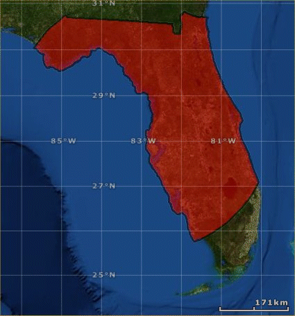
Union
Union two polygons.
Syntax
Union( polygon1, polygon2 )
Remarks
Unites the two polygons, returning a new polygon that contains all area covered by either polygon.